November Premier Auction: Day 3
Sat, Nov 11, 2017 09:00AM EST - Sun, Nov 12, 2017 09:00AM EST
| Price | Bid Increment |
|---|---|
| $0 | $25 |
| $100 | $50 |
| $1,000 | $100 |
| $2,000 | $200 |
| $3,000 | $250 |
| $5,000 | $500 |
| $10,000 | $1,000 |
| $20,000 | $2,000 |
| $50,000 | $5,000 |
| $100,000 | $10,000 |
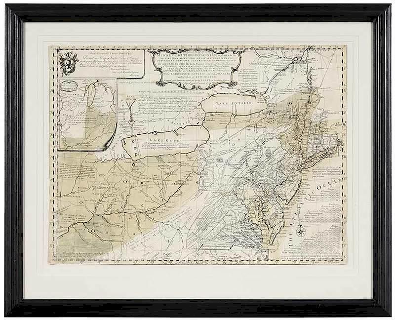
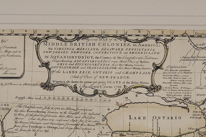
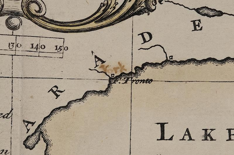
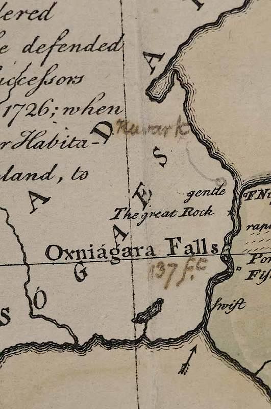
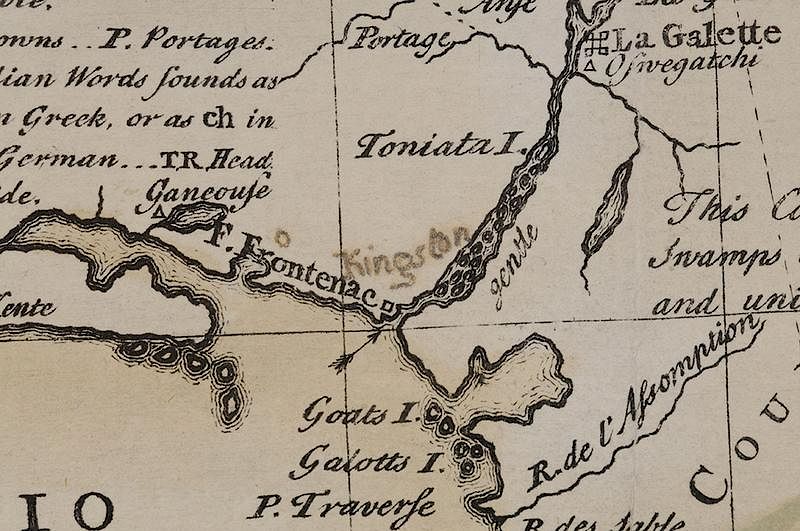
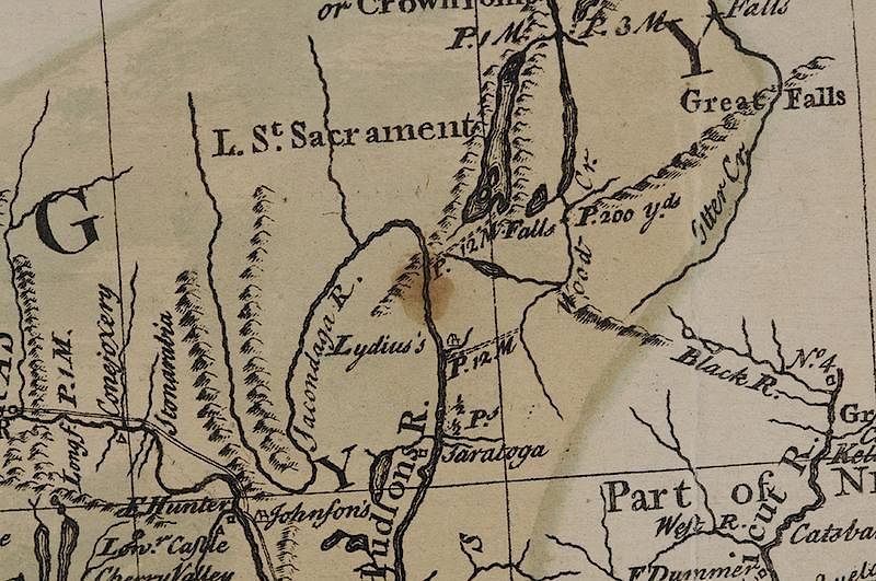
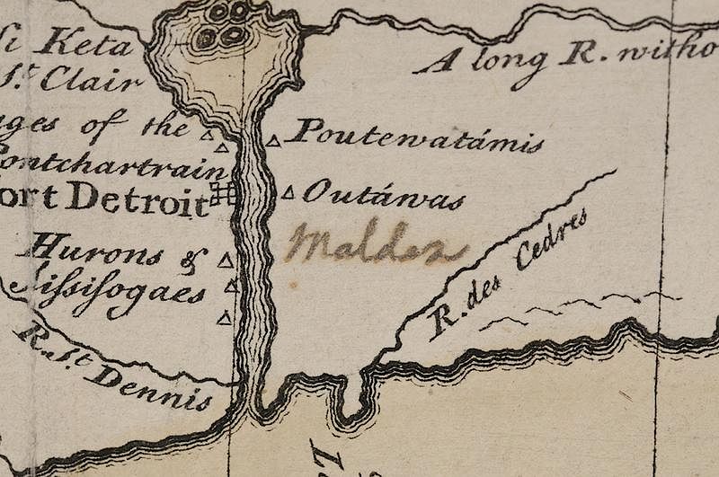
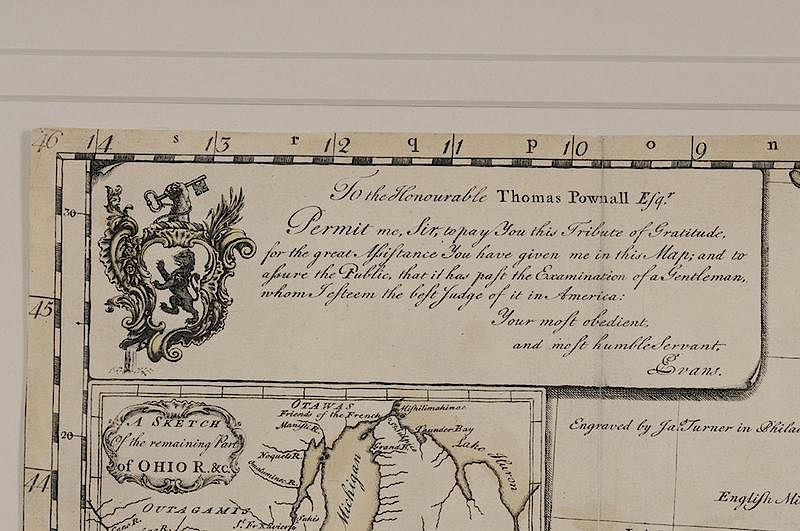
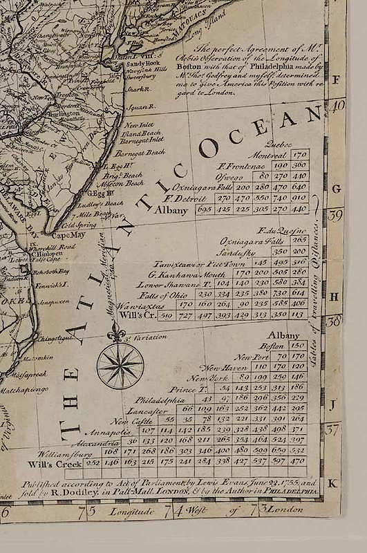
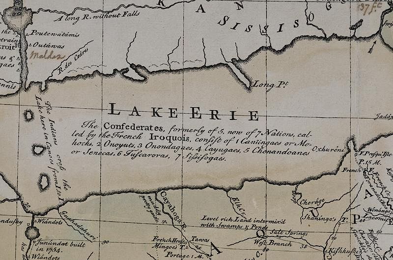
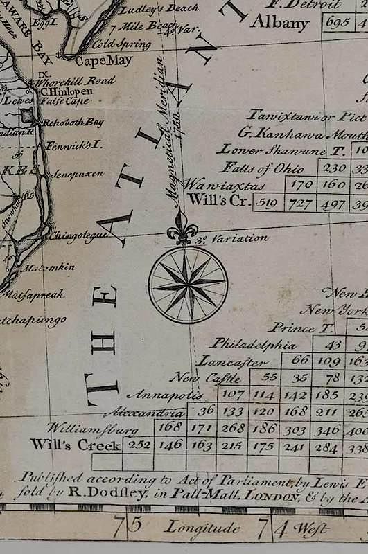
Lewis Evans (circa 1700-1756), A General Map of The Middle British Colonies, in America; Viz Virginia, Màriland, Dèlaware, Pensilvania, New-Jersey, New-York, Connecticut, And Rhode Island, 1755, James Turner (1722-1759) engraver; Robert Dodsley (1703-1764) publisher, black and white line engraving with period hand color on laid paper, 19-1/2 x 26 in.; framed Notes: Lewis Evans was the best geographer working in the English colonies in the mid-eighteenth century. Concerned over increased French activity on the frontier, Evans gathered sources in preparation for a new map of the middle colonies, placing his emphasis on the Ohio Valley, the region at the center of the friction between England and France. Maps were rarely engraved and published in America during the colonial period, however Evans commissioned James Turner, a copperplate engraver who had recently moved to Philadelphia from Boston, to execute the work. Evans’s map was widely accepted and copies were quickly pirated in London. The first plagiarized version appeared in 1756. In all, sixteen editions, all derived from Evans’s map and all piracies except for one, were published over the next sixty years. The upper center cartouche reads: A general MAP of the MIDDLE BRITISH COLONIES, in AMERICA; Viz VIRGINIA, MÀRILAND, DÈLAWARE, PENSILVANIA, NEW-JERSEY, NEW-YORK, CONNECTICUT, and RHODE ISLAND: Of AQUANISHUONÎGY, the Country of the Confederate Indians; Comprehending AQUANISHUONÎGY proper, their Place of Residence, OHIO and TÏIUXSOXRÚNTIE their Deer-Hunting Countries, COUXSAXRÁGE and SKANIADAR DE, their Beaver-Hunting Countries; of the LAKES ERIE, ONTÁRIO and CHAMPLAIN,/ And of Part of NEW-FRANCE: Wherein is also shewn the antient and present SEATS of the Indian Nations. By Lewis Evans. 1755. The upper left cartouche reads: To the Honourable Thomas Pownall Esq.r Permit me, Sir, to pay You this Tribute of Gratitutde, for the great Assistance You have given me in this Map; and to assure the Public, that it has past the Examination of a Gentleman, whom I esteem the best Judge of it in America: Your most obedient, and most humble Servant, LEvans. Below this cartouche, text reads: Engraved by Ja.s Turner in Philadelphia. The lower right corner reads: Published according to Act of Parliament, by Lewis Evans, June 23.1755. and sold by R. Dodsley, in Pall-Mall, LONDON, & by the Author in PHILADELPHIA. Exhibition History: "Degrees of Latitude: Mapping Early America"; Milwaukee Art Museum, Wisconsin, March 21, 2003 - June 22, 2003; Concord Museum, Massachusetts, July 10, 2003 - October 19, 2003; DAR Museum, Washington D.C., November 14, 2003 - February 28, 2004. Literature: Cresswell, Donald, H., "Colony to Commonwealth: The Eighteenth Century," in Stephenson, Richard W. and Marianne M. McKee, Virginia in Maps, pp. 53-54, 82; Gipson, Lawrence Henry, Lewis Evans," 1939; Klinefelter, Walter "Lewis Evans and His Maps," in Transactions of the American Philosophical Society, New Series, Vol. 61, No. 7, 1971), pp. 3-65; Papenfuse, Edward C. and Joseph M. Coale III, The Hammond-Harwood House Atlas of Historical Maps of Maryland, 1608-1908, pp. 33-34; Pritchard, Margaret B. and Henry G. Taliaferro, Degrees of Latitude: Mapping Colonial America, pp. 172-175; Seymour I. Schwartz and Ralph E. Ehrenberg, The Mapping of America, pp. 162, 165, Plate 98;Wheat, James Clement and Christian F. Brun, Maps and Charts Published in America before 1800: A Bibliography ,pp. 65-66, #298. Provenance: Colonial Williamsburg Foundation, Proceeds to Benefit the Acquisitions Fund
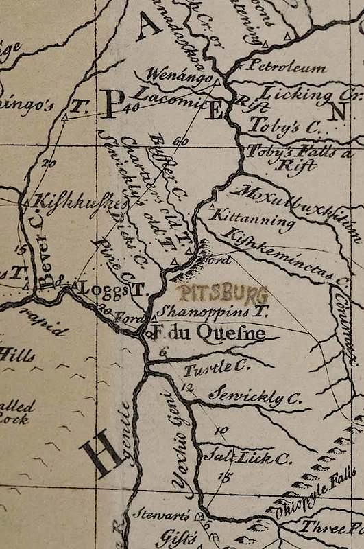
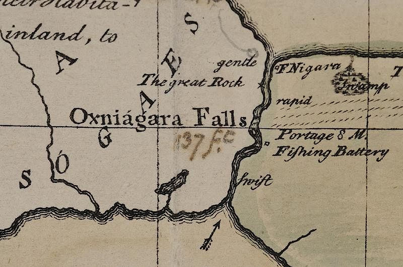
floated on archival tissue tabs, not examined out of frame, trimmed to plate or slightly inside, some slight fading at right center and at top right, flyspeck in lower left, watercolor with some light fading or fugitive pigment, light loss to lower left, some wear and handling grime at creases, session numbers in marker on back of frame, some locations inked in, possibly period, with bleed, including "Pitsburg" (Pittsburgh), "Malden", "137 fc." or "37 fc", "Kuwark" at what would later become Fort George, "York" at present day Toronto, and "Kingston"
In house shipping. Brunk Auctions provides in-house shipping via UPS Ground (signature required) for many items. Brunk Auctions will provide a shipping quote which includes shipping, materials, labor and insurance. Insurance is based on the selling price and premium.
In order to provide an accurate shipping quote please provide the following:
Shipping arrangements are made only after the invoice is paid. The payment for shipping is a separate charge from payment of your lots.
Sales Tax: If you live in North Carolina and/or pick up from the auction house, and do not have a valid resale tax number on file with us, you MUST pay North Carolina state sales tax. The NC Sales Tax will not apply to any items being shipped out of state (unless the client resides in North Carolina) or to those clients with a resale tax number.