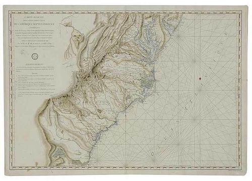
Antoine de Sartine (1729-1801) Carte Reduite des Cotes Orientales de L'Amerique Septentrionale Contenant Partie du Nouveau Jersey, la Pensylvania, la Mary-land, la Virginie, la Caroline Septentrionale, la Caroline Meridionale et la Georgie...,1778 from the rare French government-issued Neptune Americo-Septentrional, which is also known as American Neptune; Possibly after nautical work by Jacques-Nicolas Bellin (1703-1772) (uncredited), Petit (fl. 1775-1799) engraver, black and white line engraving with hand color on laid paper, 23-7/8 x 35 in. (plate), 24-5/8 x 35-5/8 in. (overall); unframed
Notes: Published as part of Neptune Americo-Septentrional for the French navy during the American Revolution, by order of Antoine Sartine, who was Minister of Marine from 1774 to 1780. Prior to the American Revolution Sartine was responsible for enlarging and modernizing the French navy, Under his administration he quadrupled the number of ships. Increased production led to the creation of 9 ships of-the-line per year by the time the French entered the Revolution in 1778. It is a well-noted fact that the French Navy was vital to the success of the American colonists in the war, most notably their impact in Siege of Yorktown. While this is primarily a nautical chart created for use by the French Navy, there is considerable inland detail, which is highlighted by vibrant period coloring.
The upper left corner reads: CARTE REDUITE/ DES COTES ORIENTALES/ DE L'AMERIQUE SEPTENTRIONALE/ CONTENANT/ Partie du Nouveau Jersey, la Pen-sylvania, la Mary-land, la Virginie,/ la Caroline Septentrionale, la Caroline Meridionale et la Georgie,/ Assujettie aux Observations les plus recentes et aux Cartes de detail les plus estimees./ Dressee au Depot General des Cartes, Plans et Journeaux de la Marine,/ POUR LES SERVICE DES VAISSEAUX DU ROI./ Par Ordre de M. DE SARTINE, Conseiller d'Etat,/ Ministre et Secretaire d'Etat ayant le Departement de la Marine./ 1778. The lower margin reads: Grave par Petit.
Literature: Phillips, Philip Lee, A List of Geographical Atlases in the Library of Congress, pp. 1211-1212; Swem, Earl G., comp. Maps Relating to Virginia in the Virginia State Library and other Departments of the Commonwealth, p. 72, #253.
Provenance: Colonial Williamsburg Foundation, Proceeds to Benefit the Acquisitions Fund
Condition
2-1/2 x 3 in. skinned area verso where there was a possible label removed (restoration), staining in lower left corner (visible verso), restoration in lower right margin (visible verso), session numbers pencilled verso, minor stain in upper left below text, minor tears in margins, toning, hand coloring possibly period or later


