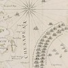
George Louis Le Rouge (fl. 1740-1780) Baye de Chesapeake en 4 Feuilles avec les Bas sonds, Passes, Entrees, Sondes et Routes ou l'on donne les parties Navigables des Rivieres Patowmack, Patapsco, et Nord-Est., dated 1778, in two sections; Anthony Smith cartographer, black and white line engraving on laid paper, upper measurement 19-1/2 x 55-3/8 in. (plate), 21-3/8 x 56-3/8 in. (overall), lower measurement 19-5/8 x 55-1/2 in. (plate), 21-3/8 x 56-7/8 in (overall); unframed
Notes: As the French entered the Revolutionary War, they anticipated the need to have maps of the Americas. Imported maps were expensive, thus it was cost effective to engrave copies locally. Le Rouge specialized in publishing French versions of English maps. This map, vital to the French naval operations in Virginia, was copied from Anthony Smith’s A New and Accurate Chart of the Bay of Chesapeake (1777), pictured in Degrees of Latitude by Margaret Beck Pritchard and Henry G. Taliaferro on pages 224-227. In 1781, French naval forces under the command of Admiral de Grasse blockaded the Chesapeake Bay in the Siege of Yorktown. The French blockade at the mouth of the Chesapeake played a vital role in this decisive victory in the American Revolution, leading to the surrender of Lord Cornwallis to General Washington.
The upper left cartouche of the top half of the map reads: BAYE DE CHESAPEAKE en 4 Feuilles avec les Bas sonds, Passes, Entrees, Sondes et Routes ou l'on donne les parties Navigables des Rivieres Patowmack, Patapsco, et Nord-Est. d'apres les Dessins de Navigateurs Experientes, principal.t d'apres A: Smith Pilote de S.t Marys,/ Compare avec les Nouvelles Levees de VIRGINIE ET MARYLAND. publie a Londres en juillet 1776. Traduit de l'Anglais. A PARIS Chez le Rouge rue des g.ds Augustins 1778. The lower right inset map in the bottom half reads: PLAN DE HERRING BAYE EN MARYLAND.
Literature: Phillips, Philip Lee, A List of Maps of America in the Library of Congress, pp. 227-228; Pritchard, Margaret B. and Henry G. Taliaferro, Degrees of Latitude: Mapping Colonial America, pp. 224-227, #48; Sellers John R. and Patricia M. Van Ee, Maps and Charts of North America and the West Indies, 1750-1789, p. 323, #1496.
Provenance: Colonial Williamsburg Foundation, Proceeds to Benefit the Acquisitions Fund
Condition
printed on four sheets and laid into two sections, watermarks visible centrally when held to light, slight loss to top section at bottom right, slight creasing at folds as laid, possible restoration to margins when laid, numbered verso in top right of both sections