Three South Carolina Maps
Bid Increments
| Price | Bid Increment |
|---|---|
| $0 | $25 |
| $100 | $50 |
| $1,000 | $100 |
| $2,000 | $200 |
| $3,000 | $250 |
| $5,000 | $500 |
| $10,000 | $1,000 |
| $20,000 | $2,000 |
| $50,000 | $5,000 |
| $100,000 | $10,000 |
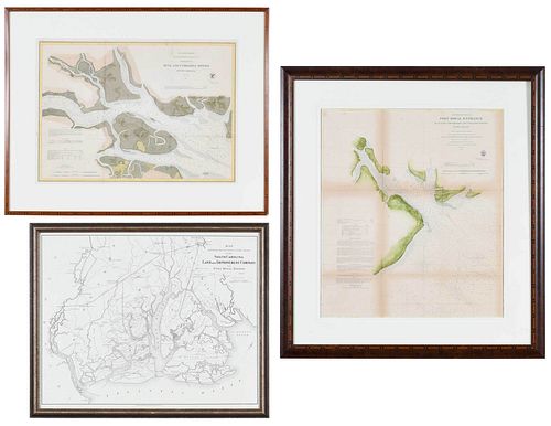
Preliminary Chart of Port Royal Entrance, Beaufort Chechessee and Colleton Rivers... U.S. Coast Survey Office, Superintendent A. D. Bache, triangulation by C. O. Boutelle... 1859, single sheet, engraving on wove paper, hand colored highlights, with tidal observations and sailing directions, sight 22-1/4 x 25-1/2 in.; Entrance to Bull and Combahee Rivers... U.S. Coast Survey Office, Superintendent Benjamin Pierce, 1871, single sheet, engraving on wove paper, hand colored highlights, with soundings, lighthouse, and tidal observations, sight 16 x 22-1/2 in.; reproduction Map showing the location of the lands of the South Carolina Land and Improvement Company on Port Royal Harbor, G.W. and C.B. Colton & Co., New York, 1877, sight 16 x 22-3/8 in.; largest frame 35-7/8 x 32-1/2 in.
Provenance: Private Bluffton, South Carolina Collection
Condition
not examined out of frames, scattered areas of toning, light staining, and handling creases throughout; Port Royal Entrance with handling creases, separation along one fold line, tear to upper left corner; frames with light wear and abrasions; Bull and Combahee Rivers frame separating at lower right corner
Purchased items will be available for pick up or shipping from our Asheville, North Carolina auction facility within ten business days of the auction will be assessed a storage fee of $5.00 per day, per item. Purchaser agrees that packing and shipping is done at the purchaser's risk and that the purchaser will pay in advance all packing expenses, materials, carrier fees and insurance charges. At our discretion, items will either be packed by an agent such as a packaging store or Brunk Auctions. Please allow two weeks for shipping after payment is received. Shipment of large items is the responsibility of the purchaser. We are happy to provide names of carriers and shippers if a purchaser so requests. Brunk Auctions will have no liability for any loss or damage to shipped items.


