Lot 146
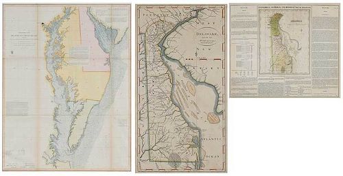
Three Framed Maps of Delaware/Chesapeake Bays
Estimate: $400 - $600
Sold for
$400
Sold Price excludes BP
Bid Increments
| Price | Bid Increment |
|---|---|
| $0 | $25 |
| $100 | $50 |
| $1,000 | $100 |
| $2,000 | $200 |
| $3,000 | $250 |
| $5,000 | $500 |
| $10,000 | $1,000 |
| $20,000 | $2,000 |
| $50,000 | $5,000 |
| $100,000 | $10,000 |
Preliminary Chart of Delaware and Chesapeake Bays and the Sea Coast from Cape Henlopen to Cape Charles, Coast Survey Office, 1855, including tide chart and sailing directions, colored highlights, with certificate of authenticity, 31-1/2 x 25-1/4 in. (sight); Delaware from the best Authorities, Mathew Carey (1760-1839), Philadelphia, late 18th/early 19th century, hand colored highlights, 16-1/2 x 9-1/2 in. (sight); Geographical, Statistical, and Historical Map of Delaware,˜Carey & Lea, Philadelphia, circa 1822, details including "Historical Sketch", "List of Governors &c.", "Civil Divisions and Population," etc., colored highlights, 17-1/4 x 21 in. (sight); all framed, largest 39-1/4 x 33 in., Provenance: Private Collection, Gibson Island, Maryland
not examined out of frames, all with some toning, staining, fading, and creasing; frames with abrasions and gilt/paint loss
Condition
Purchaser agrees that packing and shipping is done at the purchaser’s risk and that the purchaser will pay in advance all packing expenses, materials, carrier fees and insurance charges. At our discretion, items will either be packed by an agent such as a packaging store or Brunk Auctions. Please allow two weeks for shipping after payment is received. Shipment of large items is the responsibility of the purchaser. We are happy to provide names of carriers and shippers if a purchaser so requests. Brunk Auctions will have no liability for any loss or damage to shipped items. Items purchased from our Asheville auction facility not picked up within ten business days of the auction will be assessed a storage fee of $5.00 per day, per item.


