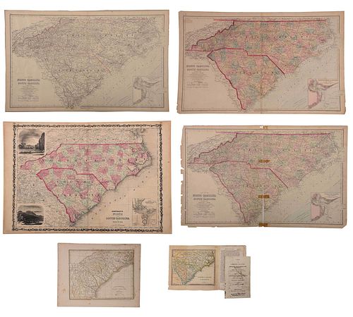
Six 19th Century Maps of North and South Carolina
Bid Increments
| Price | Bid Increment |
|---|---|
| $0 | $25 |
| $100 | $50 |
| $1,000 | $100 |
| $2,000 | $200 |
| $3,000 | $250 |
| $5,000 | $500 |
| $10,000 | $1,000 |
| $20,000 | $2,000 |
| $50,000 | $5,000 |
| $100,000 | $10,000 |
six maps, engravings on wove paper, some with hand colored highlights, all unframed, including: three examples of Frank Gray, Gray's New Map of North and South Carolina, Philadelphia, circa 1881; Johnson and Ward, Johnson's North and South Carolina, New York, circa 1862, from Johnson's New and Illustrated Family Atlas; T.G. Bradford, North Carolina, South Carolina, and Georgia, Boston, circa 1835; map of North and South Carolina and several pages from View of the United States, Historical, Geographical, and Statistical... by William Darby, Philadelphia: H.S. Tanner, 1828; largest sheet 18 x 26-3/4 in.
Provenance: Humber Family, North Carolina
Condition
all with some toning, scattered wear and small tears to edges, some handling creases; one example of Gray's map separated and taped together along front of join line, several tears at edges; one example of Gray's map laid down on board; Bradford map with some foxing
Purchased items will be available for pick up or shipping from our Asheville, North Carolina auction facility within ten business days of the auction will be assessed a storage fee of $5.00 per day, per item. Purchaser agrees that packing and shipping is done at the purchaser's risk and that the purchaser will pay in advance all packing expenses, materials, carrier fees and insurance charges. At our discretion, items will either be packed by an agent such as a packaging store or Brunk Auctions. Please allow two weeks for shipping after payment is received. Shipment of large items is the responsibility of the purchaser. We are happy to provide names of carriers and shippers if a purchaser so requests. Brunk Auctions will have no liability for any loss or damage to shipped items.


