Premier Catalog Auctions - Session III
Sat, Sep 15, 2018 09:00AM EDT

| Price | Bid Increment |
|---|---|
| $0 | $25 |
| $100 | $50 |
| $1,000 | $100 |
| $2,000 | $200 |
| $3,000 | $250 |
| $5,000 | $500 |
| $10,000 | $1,000 |
| $20,000 | $2,000 |
| $50,000 | $5,000 |
| $100,000 | $10,000 |
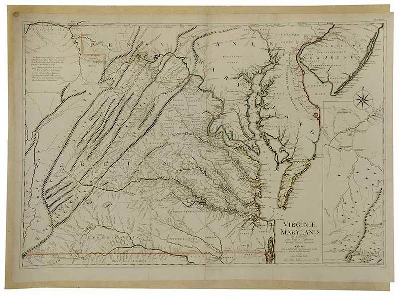
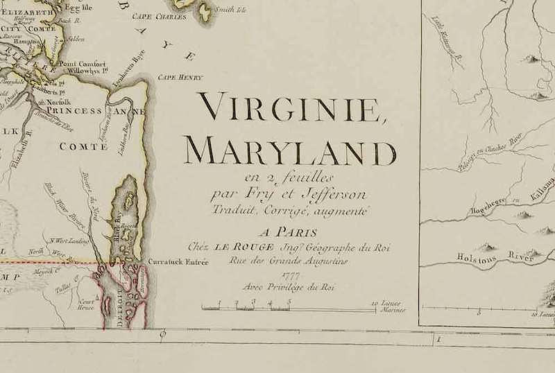
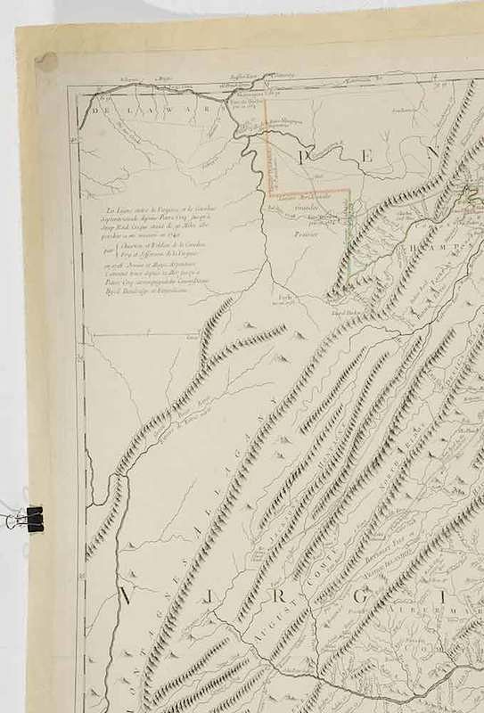
George Louis Le Rouge (fl. 1740-1780), after work by Joshua Fry (1700-1754) and Peter Jefferson (1708 - 1757) Virginie, Maryland en 2 feuilles par Fry et Jefferson Traduit, Corrigé, augmenté a Paris Chez Le Rouge Ing'r Geographe du Roi Rue des Grands Augustins 1777, dated 1777, black and white line engraving with period outline color mounted on linen, 27 x 39-3/4 in. (plate), 30-7/8 x 41-7/8 in. (overall); unframed
Note: This copy of the map was published in William C. Wooldridge, Mapping Virginia, figure 110, pp. 114, 116-117.
As tension mounted between the British and their American colonies, French cartographers anticipated the need to have maps of the Americas. Imported maps were expensive, thus it was cost-effective to engrave copies locally. Le Rouge specialized in publishing French versions of English maps. This map, which has become rarer today than its English prototype, is Le Rouge’s faithful copy of Fry and Jefferson’s map of Virginia and Maryland.
States of this map are held in the Library of Congress and in the Huntingfield Rare Map Collection in the Maryland State Archives.
Literature: Cumming, William P., The Southeast in Early Maps, 1962, 219-21; Verner, Coolie, [unpublished] Notes On The Maps Of Virginia, # 623, 630, 644, 699, 723, 739, 742, 759, 793, and 904; Verner, Coolie, [unpublished] Notes On The Maps Of Virginia, # 623, 630, 644, 699, 723, 739, 742, 759, 793, and 904.
, Provenance: Collection of William C. Wooldridge; Collection of the Virginia Cartographical Society, LC; deaccessioned by the Colonial Williamsburg Foundation, Williamsburg, Virginia with all proceeds to benefit the Collections Acquisitions Fund.In house shipping. Brunk Auctions provides in-house shipping via UPS Ground (signature required) for many items. Brunk Auctions will provide a shipping quote which includes shipping, materials, labor and insurance. Insurance is based on the selling price and premium.
In order to provide an accurate shipping quote please provide the following:
Shipping arrangements are made only after the invoice is paid. The payment for shipping is a separate charge from payment of your lots.
Sales Tax: If you live in North Carolina and/or pick up from the auction house, and do not have a valid resale tax number on file with us, you MUST pay North Carolina state sales tax. The NC Sales Tax will not apply to any items being shipped out of state (unless the client resides in North Carolina) or to those clients with a resale tax number.