Premier Catalog Auctions - Session III
Sat, Sep 15, 2018 09:00AM EDT

| Price | Bid Increment |
|---|---|
| $0 | $25 |
| $100 | $50 |
| $1,000 | $100 |
| $2,000 | $200 |
| $3,000 | $250 |
| $5,000 | $500 |
| $10,000 | $1,000 |
| $20,000 | $2,000 |
| $50,000 | $5,000 |
| $100,000 | $10,000 |
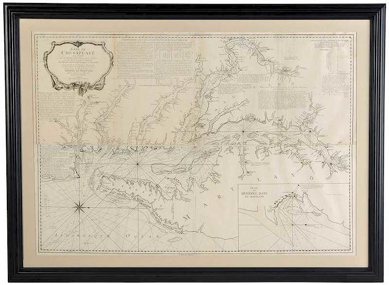
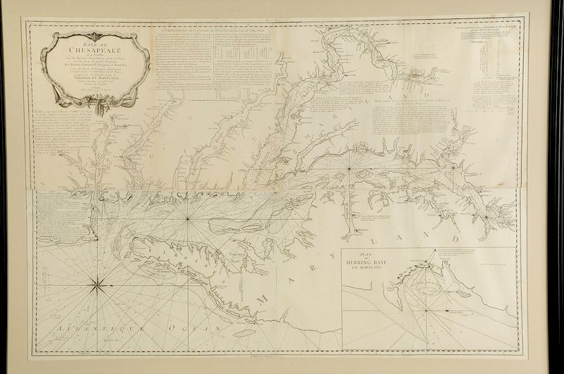
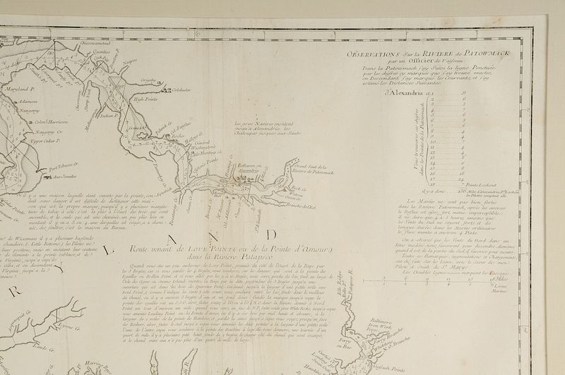
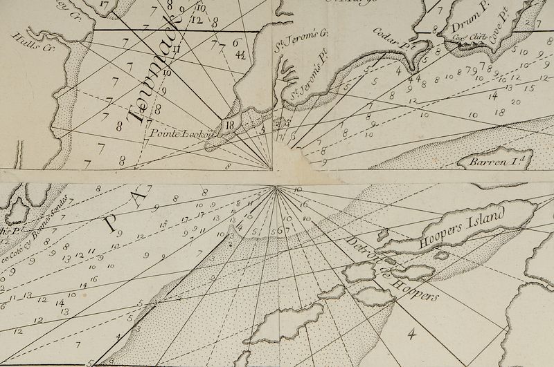
George Louis Le Rouge (fl. 1740-1780) Baye de Chesapeake en 4 Feuilles avec les Bas sonds, Passes, Entrees, Sondes et Routes ou l'on donne les parties Navigables des Rivieres Patowmack, Patapsco, et Nord-Est..., Paris, dated 1778; Anthony Smith cartographer, black and white line engraving on laid paper, 37-1/4 x 54-1/4 in. (sight), framed
Note: As the French entered the Revolutionary War, they anticipated the need to have maps of the Americas. Imported maps were expensive, thus it was cost effective to engrave copies locally. Le Rouge specialized in publishing French versions of English maps. This map, vital to the French naval operations in Virginia, was copied from Anthony Smith’s A New and Accurate Chart of the Bay of Chesapeake (1777), pictured in Degrees of Latitude by Margaret Beck Pritchard and Henry G. Taliaferro on pages 224-227. In 1781, French naval forces under the command of Admiral de Grasse blockaded the Chesapeake Bay in the Siege of Yorktown. The French blockade at the mouth of the Chesapeake played a vital role in this decisive victory in the American Revolution, leading to the surrender of Lord Cornwallis to General Washington.
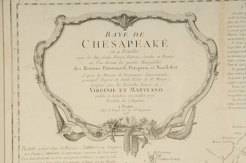
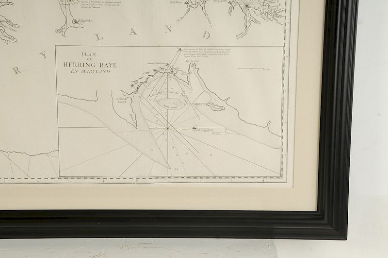
The upper left cartouche of the top half of the map reads: BAYE DE CHESAPEAKE en 4 Feuilles avec les Bas sonds, Passes, Entrees, Sondes et Routes ou l'on donne les parties Navigables des Rivieres Patowmack, Patapsco, et Nord-Est. d'apres les Dessins de Navigateurs Experientes, principal.t d'apres A: Smith Pilote de S.t Marys,/ Compare avec les Nouvelles Levees de VIRGINIE ET MARYLAND. publie a Londres en juillet 1776. Traduit de l'Anglais. A PARIS Chez le Rouge rue des g.ds Augustins 1778. The lower right inset map in the bottom half reads: PLAN DE HERRING BAYE EN MARYLAND.
Literature: Phillips, Philip Lee, A List of Maps of America in the Library of Congress, pp. 227-228; Pritchard, Margaret B. and Henry G. Taliaferro, Degrees of Latitude: Mapping Colonial America, pp. 224-227, #48; Sellers John R. and Patricia M. Van Ee, Maps and Charts of North America and the West Indies, 1750-1789, p. 323, #1496.
, Provenance: Deaccessioned from MESDA and Old Salem to benefit the Acquisition FundIn house shipping. Brunk Auctions provides in-house shipping via UPS Ground (signature required) for many items. Brunk Auctions will provide a shipping quote which includes shipping, materials, labor and insurance. Insurance is based on the selling price and premium.
In order to provide an accurate shipping quote please provide the following:
Shipping arrangements are made only after the invoice is paid. The payment for shipping is a separate charge from payment of your lots.
Sales Tax: If you live in North Carolina and/or pick up from the auction house, and do not have a valid resale tax number on file with us, you MUST pay North Carolina state sales tax. The NC Sales Tax will not apply to any items being shipped out of state (unless the client resides in North Carolina) or to those clients with a resale tax number.