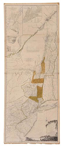
Holland - The Provinces of New York and New Jersey
Bid Increments
| Price | Bid Increment |
|---|---|
| $0 | $25 |
| $100 | $50 |
| $1,000 | $100 |
| $2,000 | $200 |
| $3,000 | $250 |
| $5,000 | $500 |
| $10,000 | $1,000 |
| $20,000 | $2,000 |
| $50,000 | $5,000 |
| $100,000 | $10,000 |
Samuel Johannes Holland (Dutch, 1728-1801),ÿThe Provinces of New York, and New Jersey; with part of Pensilvania and the Province of Quebec, published by Sayer and Bennett, London, 1776, fifth state, in twoÿsheets, engraving on laid paper with minimal hand colored highlights, top sheet numbered "17" verso, with three insets at upper left: "A Chart of the Mouth of Hudson's River from Sandy Hook to New York", "A Plan of Amboy", and "A Plan of the City of New York", sheet 54-1/8 x 21-3/4 in., plate 53-1/2 x 21-1/8 in.;ÿcarved, painted, and giltwood frame, 60 x 27-1/4 in.; together with a print reproduction of Thomas Jeffreys'ÿA map of the most inhabited part of New England..., London, 1774; framed, 32-1/8 x 31-1/8 in.
Provenance: The Ann and Joel Finn CollectionCondition
laid down along three horizontal lines, some wear and small edge tears at edges, two repairs to bottom margin (each extending about 2 inches into plate); reproduction Jeffreys map not examined out of frame; frames with light wear and abrasions
Purchased items will be available for pick up or shipping from our Asheville, North Carolina auction facility within ten business days of the auction will be assessed a storage fee of $5.00 per day, per item. Purchaser agrees that packing and shipping is done at the purchaser's risk and that the purchaser will pay in advance all packing expenses, materials, carrier fees and insurance charges. At our discretion, items will either be packed by an agent such as a packaging store or Brunk Auctions. Please allow two weeks for shipping after payment is received. Shipment of large items is the responsibility of the purchaser. We are happy to provide names of carriers and shippers if a purchaser so requests. Brunk Auctions will have no liability for any loss or damage to shipped items.


