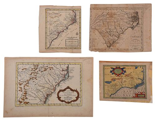
Four 17th and 18th Century Maps of the Southeast
Bid Increments
| Price | Bid Increment |
|---|---|
| $0 | $25 |
| $100 | $50 |
| $1,000 | $100 |
| $2,000 | $200 |
| $3,000 | $250 |
| $5,000 | $500 |
| $10,000 | $1,000 |
| $20,000 | $2,000 |
| $50,000 | $5,000 |
| $100,000 | $10,000 |
engravings on laid paper, some with hand colored highlights, all unframed, including: Jacques-Nicolas Bellin (1703-1772), Carte De La Caroline et Georgie..., Paris, circa 1757, plate 8 x 11-3/4 in., sheet 10-1/8 x 15 in.; J. Denison, Map of North and South Carolina, engraver Amos Doolittle, Boston, 1796, for Morse's Universal Geography, sheet 8-1/2 x 10-5/8 in.; Herman Moll (circa 1654-1732), Carolina, London, circa 1708, from John Oldmixon's The British Empire in America, sheet 8-1/4 x 7-1/4 in.; Jodocus Hondius (1563-1612), Virginia et Florida, Amsterdam, circa 1635, published in Historia Mundi: or Mercator's Atlas, sheet approximately 7 x 9 in.
Provenance: Humber Family, North Carolina
Condition
all with some toning and light staining throughout, light wear to edges; Denison map moderately toned, some offsetting to right side; Hondius map laid down on board, some losses to sheet
Purchased items will be available for pick up or shipping from our Asheville, North Carolina auction facility within ten business days of the auction will be assessed a storage fee of $5.00 per day, per item. Purchaser agrees that packing and shipping is done at the purchaser's risk and that the purchaser will pay in advance all packing expenses, materials, carrier fees and insurance charges. At our discretion, items will either be packed by an agent such as a packaging store or Brunk Auctions. Please allow two weeks for shipping after payment is received. Shipment of large items is the responsibility of the purchaser. We are happy to provide names of carriers and shippers if a purchaser so requests. Brunk Auctions will have no liability for any loss or damage to shipped items.


