November Premier Auction: Day 3
Sat, Nov 11, 2017 09:00AM EST - Sun, Nov 12, 2017 09:00AM EST
| Price | Bid Increment |
|---|---|
| $0 | $25 |
| $100 | $50 |
| $1,000 | $100 |
| $2,000 | $200 |
| $3,000 | $250 |
| $5,000 | $500 |
| $10,000 | $1,000 |
| $20,000 | $2,000 |
| $50,000 | $5,000 |
| $100,000 | $10,000 |
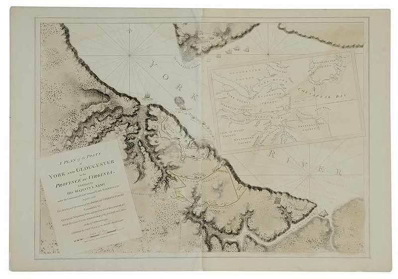
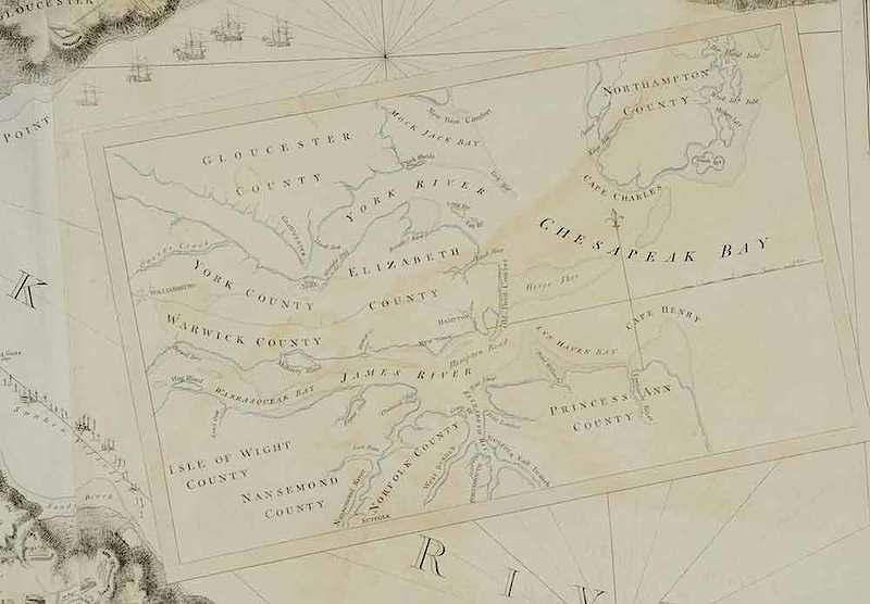
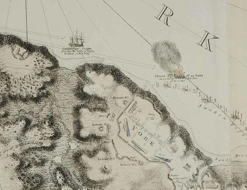
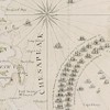
Joseph Frederick Wallet Des Barres (1721-1824), A Plan of the Posts of York and Gloucester in the Province of Virginia. Established by His Majesty's Army under the Command of Lieu't General Earl Cornwallis, together with The Attacks and Operations of the American & French Forces Commanded by General Washington and the Count of Rochambeau, which Terminated in the Surrender of the said Posts and Army on the 17th of October 1781. Surveyed by Captn. Fage of the Royal Artillery, published according to Act of Parliament, the 4th June 1782, black and white line engraving with period color, 29-3/4 x 40-1/2 in. (plate), 32-1/4 x 46 in. (overall); unframed Notes: This copy of the map was published in William C. Wooldridge, Mapping Virginia, figure 156, pp. 171-174. Yorktown was built on a bluff at a point where the York River is about one-half-mile wide. Yorktown Creek to the northwest and “Wormsley” (Wormley) Creek to the southeast created natural ravines. A Plan of the Posts of York and Gloucester illustrates the troop, redoubt, and battery positions of the allied and British armies around Yorktown. Compiled by Captain Edward Fage, this map was published by Joseph Frederick Wallet Des Barres in his multivolume atlas, The Atlantic Neptune. Due to the great cost of publication, this multi-volume atlas would probably have never seen the light of day if not for the worsening conditions in the American Colonies. Approximately 160 charts were produced before publication ceased in 1782, and no two examples of the atlas have the same collation. These volumes were issued throughout the Revolution to the British Royal Navy and were assembled according to the specific tour of duty. Since the Southern campaigns took place during the end of the war, the maps that Des Barres issued for these regions are exceedingly rare. Another copy of this map sold at Brunk Auctions for $120,000 on November 7, 2015, lot 396. Literature: Pritchard, Margaret B. and Henry G. Taliaferro, Degrees of Latitude: Mapping Colonial America, pp. 286-289; Verner, Coolie. “Maps of the Yorktown Campaign, 1780-1781,” (Map Collector’s Series); Verner, Coolie (unpublished) The Printed Maps of Virginia 1590 to 1800, Vol. 5, no. 788; see Hornby, Surveyors of Empire Samuel Holland, J. F. W. Des Barres and the Making of the Atlantic Neptune, Phillips, Atlases in the Library of Congress, 1198-1204. Provenance: Colonial Williamsburg Foundation, Proceeds to Benefit the Acquisitions Fund
tears and losses mended in conservation to corners, lower right edge, center crease, top and center right, and left edge; text transfer mostly visible on right section, more faint on the left; pigment transfer from hand coloring parallel with opposite section visible throughout (due to the map being folded), "J. Bates" watermark visible with light at bottom left and top right, pigment stain at bottom right (likely from original hand coloring), staining and pigment degradation, slight toning
In house shipping. Brunk Auctions provides in-house shipping via UPS Ground (signature required) for many items. Brunk Auctions will provide a shipping quote which includes shipping, materials, labor and insurance. Insurance is based on the selling price and premium.
In order to provide an accurate shipping quote please provide the following:
Shipping arrangements are made only after the invoice is paid. The payment for shipping is a separate charge from payment of your lots.
Sales Tax: If you live in North Carolina and/or pick up from the auction house, and do not have a valid resale tax number on file with us, you MUST pay North Carolina state sales tax. The NC Sales Tax will not apply to any items being shipped out of state (unless the client resides in North Carolina) or to those clients with a resale tax number.