Lot 1161
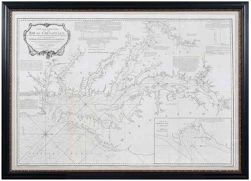
A New and Accurate Chart of the Bay of Chesapeake
Estimate: $40,000 - $60,000
Bid Increments
| Price | Bid Increment |
|---|---|
| $0 | $25 |
| $100 | $50 |
| $1,000 | $100 |
| $2,000 | $200 |
| $3,000 | $250 |
| $5,000 | $500 |
| $10,000 | $1,000 |
| $20,000 | $2,000 |
| $50,000 | $5,000 |
| $100,000 | $10,000 |
Anthony Smith, A New and Accurate Chart of the Bay of Chesapeake...with All the Shoals, Channels, Islands, Entrances, Soundings, and Sailing Marks, as Far as the Navigable Parts of the Rivers Patomack, Patapsco, and North-East..., Published by Sayer and Bennett, London, 1776, third state, in four sheets, engraving on laid paper, sheet 38-1/2 x 56 in.; framed, 45-1/2 x 62-3/4 in.
Provenance: The Old Print Shop, New York, New York;
Literature: Pritchard and Taliaferro, Degrees of Latitude, Colonial Williamsburg Foundation, 2002, pg. 224-227
Condition
floated on mat with archival tape at all edges, trimmed to plate at lower margin, some light browning at margins; frame with light wear and abrasions
Purchased items will be available for pick up or shipping from our Asheville, North Carolina auction facility within ten business days of the auction will be assessed a storage fee of $5.00 per day, per item. Purchaser agrees that packing and shipping is done at the purchaser's risk and that the purchaser will pay in advance all packing expenses, materials, carrier fees and insurance charges. At our discretion, items will either be packed by an agent such as a packaging store or Brunk Auctions. Please allow two weeks for shipping after payment is received. Shipment of large items is the responsibility of the purchaser. We are happy to provide names of carriers and shippers if a purchaser so requests. Brunk Auctions will have no liability for any loss or damage to shipped items.
The Old Print Shop, New York, New York;


